|
eqMapper v2.2.0
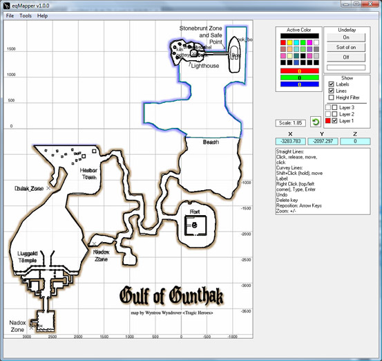
eqMapper is an offline map editor for the game of Everquest.
[2.2.0]
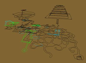
* Stereoscopic mode!  get some Red & Blue 3d glasses!  You can finally make sense of the blackburrow map
* Fixed a bug where the program would crash if you tried to select a black line.

[2.1.1]
* the auto center/auto scale function has been revamped and is much faster, more efficent, and more accurate
  this also has the side effect of setting the center of the map as the default zoom point, for when you are
  zooming using the slider rather than the mouse wheel.  Clicking elsewere on the map will still reset the
  zoom center to that location, however.
* the "refresh display" button no longer serves a purpose and has been removed

[2.1.0]
* a default background image is now loaded which looks like the parchment seen in the map window in EQ
* labels now have a dot showing the exact point of the label (top,left corner)
* the selection radius has been reduced to allow for more accurate selection of objects
* when using the zoom slider, the last place you clicked on the map will now be the center point for the zoom
* it is now possible to make a map from scratch although it's a bit tricky to calibrate the coordinate system:
  - Load a background image that shows at least 2 known LOCs
  - use the crosshair tool to pinpoint one of the locs, and then at that loc right click and type in the loc
    into the textbox that comes up, this will align the coordinate system to that loc
  - now to set the scale switch to the label tool and label the second loc, use the loc shown on the eqMapper form *NOT*
    the one on the background image as a reference.
  - hover your mouse over the first loc point and use the scroll wheel (use shift for fine adjustment) to adjust the
    scaling until the second loc is in the correct place over the background image.
  - this should calibrate the coordinate system with the background image.  Feel free to delete the label you made but
    don't adjust the scaling or panning until you have drawn some lines or you will loose your frame of reference.
* you can now do a keyword search for labels, this helps locate NPCs, zone lines, bankers etc... any matching (or
  partially matching) label will be selected as if you had clicked on it
* there is a button to automatically pan & zoom the map until it is fully on the screen for when you get lost or
  if you load a map and don't see anything (because all of its content is off screen).  This function is a little
  buggy still and sometimes requires you to re-center the content and run it again.  Still it's worth including.
* the way selected items flash has changed, and the way the screen is drawn has been optimized a bit
* if you use the pointer tool and click on nothing, you will deselect all.  Now, if you hold down CTRL this feature
  will be disabled.  While CTRL is held down you can only add to your selection, you cannot unselect items at that time.
* label fonts now get larger as you zoom in, and smaller as you zoom out.  But never get smaller than the original font

size.

[2.0.0]
* there is now a row of tool icons to switch between the various things your mouse can do rather than the complex
system of right clicking, control clicking, alt clicking, etc...
* the background image will now resize to fill the available space, while maintaining an appropriate aspect ratio
between width & height
* It is now easier to select lines using the pointer tool, and the select by region (drawing a box) tool works in
any direction, not just down and to the right
* when selecting items, if it's not on the screen (labels turned off, lines that dont show up because of the height
filter etc) it shouldn't be selected
* you can unselect stuff by using the pointer tool on a blank area
* there is a crosshair tool that lets you mark a location, while making no change to the map file itself
* zooming is easier, there is a slider to zoom which does this with the loc 0,0 as the center of the zoom.  When
using the mouse scroll wheel the zoom, the mouse position is the center of the zoom
* the z-key is still used, hold down to switch the mouse scroll wheel to the mode where it changes z-level (for
the height filter).  This is unchanged.
* the shift key now makes zooming (and z-level changing) more fine (slower), so the default is course (faster)
this is the opposite from the previous version.
* the escape key is still used to end line drawing mode.
* the delete key is still used to either delete the currently selected items, or if no items are selected the
last line or label to be loaded (or created)
* right click will temporarily switch to the pan tool, letting go returns to whatever tool you had previously selected.

[1.1.1]
 * Selected items now flash, although this can be turned off
 * If a selected item is already the highlight color (yellow), it will be highlighted by an inverse color

[1.1.0]
 * The mesh overlay has been redone, it can now be left on even while editing and doesn't take forever to draw.
 * The bounding box used to select lines & labels now can be drawn faster
 * There are indicators showing which keys are pressed (ctrl,shift,z, alt [although alt has no function currently])
   Sometimes a key may be stuck, where the program thinks it's pressed when it isn't or vice versa.  Clicking on
   the indicator will toggle it.
 * The X/Y coords are opposide (-/+) and inverted x=y, y=x from the typical LOC you see when you type /loc in the game
   Therefore, below the coords is a label showing your LOC (where the mouse is).  This should make it easier
   to say... mark a spot where an NPC is or something.
 * When a line or label has the same color as the background color it becomes invisible.  When that happens the
   program will now invert the color of that line or label so that it can be seen.  This only affects how you
   see it in eqMapper, it will still save with the correct color.  Also this option can be disabled.
   The only catch to this is if the background & line/label is at 50% grey (128,128,128) because the inverse of
   that is the same color.
 * When you save layers, if you have put content into a layer that didn't have a file associated with it you
   will be asked for a file to save it to.
[ Screen 1 | Screen 2 | Screen 3 | Screen 4 ] 
|

